Lacking in pictures because even in 2014, embedding images from alternate sources in a blog post is ridiculous UX fail!
In March (19-25), Raj, Michaela, Roxana and I went on a 6 day trip to Utah. The
itinerary was to fly into Salt Lake City, drive to Moab, do a 4 day backpacking
and packrafting trip in Canyonlands NP, spend a day in Arches NP and head back.
It was one of the best trips I’ve done and a splendid (and early!) start to
this year’s trips.
The backpacking trip was based on one covered in Backpacker
magazine
but modified to fit our schedule and capabilities. We’d start from the Elephant
Hill TH in the Needles District, hike down to the Colorado at Spanish Bottom
and cross it by packraft. Then hike up to the Doll House, hike north to the
Harvest Scene, head east to Water Canyon, then go off the established trail to
follow Water Canyon to the Green River. From there we’d raft down to Spanish
Bottom and hike out. It was some 36 miles of hiking and 8 miles rafting over
4 days.
We used Alpacka rafts rented from Packraft
Rentals at $150 for the raft, paddles and PFDs.
Having visited Moab before, Michaela was our “guide”. The Moab Brewery for
dinner was a very good recommendation! With the final civilized meal consumed,
we drove 2 more hours to the Canyonlands Needles district. All the walk-in
campsites in the park were taken (2 people actually refused to share a campsite
with us, which was very rude considering how much space there was per site!),
so we drove back 20 minutes to the privately run campsite called Needles
Outpost ($20/night).
It turned out to be a very cold night, making it hard to leave the sleeping
bag. The reward for getting out was the incredible views of canyon country, the
first time we saw it after driving in in the dark. The Needles Outpost itself
is in a fairly large plateau so that you can look far away to the Needles
rising beautifully in the west, while also seeing the pinnacles of Indian Creek
and more distant areas in the east. While I missed sunrise, reds, browns and
yellows were still shimmering and changing in the early morning Sun.
At the ranger station we found out that the established campsites throughout
the park are only for car campers, and backpackers have to practice dispersed
camping. While not a deal breaker, it was surprising, since the website doesn’t
mention this. We also spoke to the ranger at Hans Flat over the telephone who
told us that there were no reliable sources of water except the Colorado and
a few springs near the Harvest Scene, so we tanked up with 4 liters each.
NOTE: WAG bags are a good idea in Canyonlands since the climate is too dry
for waste to decompose quickly. Please use them! They are required by law
when camping near rivers.
We eventually set out at 11 from the car. Boy were the packs heavy with
several days of food, 4 liters of water and 4kg of raft! The
journey from the Elephant Hill TH to the river is relatively uneventful, though
very beautiful. The trail follows the 4 wheel drive road to Devil’s Lane,
where it goes westward into the sheer wall ahead. Go into the clump of trees to
climb onto the wall and follow it to get on the trail for Cyclone Canyon and
Lower Red Lake.

The last 1.5 miles of the Needles hike are very different from the beginning.
The canyons become taller and narrower, and the rock is now a dark red. Here it
seems like the original trail has been closed due to rockfall, because the
National Geographic map is not congruent with the new trail which climbs along
the southern canyon walls before beginning a steep descent into Lens Canyon.
Then it’s a mile of walking on sand, making your own path along the dry river
bed to Spanish Bottom. We reached the bottom around 5pm. The Needles side of
Spanish Bottom is a expansive beach and while everyone wanted to relax
I refused to let them do so. The N-S orientation of the river at this point and
the 1400ft high cliff walls on the western side means that sunset comes early.
So at 5:30 we began inflating our rafts. While doing so, a group of real
motorized rafts went down the Colorado as a guided rafting trip. Raj’s raft had
developed a puncture and needed a second inflation after patching it up.
Frankly, it was too much work to get across 30-40m of calm water. My thoughts
about the rafts were to improve only a little over the next few days.
I should point out one constant nagging feeling I had the whole trip. This
whole place is made for climbing. Everywhere, the sandstone has straight
cracks running through it, towers that rise above the canyons and even the
occasional boulder at a canyon bottom is very inviting. It is isolated though,
and I’d imagine lugging equipment and supplies would be as bad as hauling our
rafts. No wonder climbers stick to Indian Creek.
Slightly downstream, where the Colorado begins to turn east, there are
noticeable steps on the western bank and an obvious campsite. The steps are
also in an area of exceptionally still water so there isn’t any fear of being
swept downstream while trying to land. The 30ft length of cord I’d brought
along proved immensely useful this entire trip. Hooking it to a rock allowed me
to clamber out of the raft without worrying about my boat and pack, and it was
our anchor for the last night along the river. The Green and the Grand (now
called the
Colorado)
carry tons of silt down their course and that and the sandy banks means that
transitioning back to land is a muddy affair.
Once all 4 boats had been pulled in and no one had been lost to the river we
setup camp. The rangers had advised us that Colorado water was far too silty to
use filters, but with a Sawyer Mini and carrying the backflow syringe, I didn’t
face any problems. Using the cord tied to a Smartwater bottle, and using my
foot to hold the bottle down allowed retrieving water without falling into the
river. Tomorrow would be a long day with no water again till the very end, and
so I filled 7 liters to last through the night and day.
At this point Roxana couldn’t find her tent and we figured at best it was left
behind in the car, and at worst lost, but that she’d be spending the next
3 nights without one. Which isn’t a bad deal at all when the weather is great.
For tonight she’d be sleeping over her inflated packraft, her fancy solar
powered lamp on a stake next to her.
Although we were tired and dirty, the twin annoyances of the desert - dryness
and gritty sand in everything - had not yet begun to gnaw on us. We went to bed
in high spirits.
Day 2: The first night in the wilderness was quite warm, with temperatures
probably hovering around 5C. This was to be true all 3 nights and I can’t
fathom why that first night at Needles Outpost had been so cold.
We woke up around 7 (the alarm was for 6, but I was tired and it was still dark
outside!) and were ready to roll by 9:30. Packing the rafts had taken up at
least 30 minutes of our time. Today seemed like it would be the day of most
effort. We had to carry the rafts and plenty of water and most of our food up
1400ft and 2 miles followed by 3 miles on a very gentle uphill to Chimney Rock.
As we started up the southwestern side of Spanish Bottom, we encountered
a group of day hikers from the guided trip we’d seen last night. They had
camped before the start of the Cataract Canyon rapids and were on a quick jaunt
to the Doll House before (I guess) hitting the rapids. Compared to them, we
looked like pack mules! The load on our backs was - our standard pack, the
middle halves of the oars sticking out of the side pockets and the paddles
in the outer pocket of the pack. The PFD was hooked onto the oars,
and then the raft lashed to the bottom or top of the pack. With my relatively
fragile pack, I also carried my water in the front in a daypack to avoid
overloading it.
Nevertheless we completed the steepest of the ascent in a swift 45 minutes
(considering our loads) and were at the Doll House within the hour. Here we
could not find the restrooms we hoped for. Carrying waste around is nobody’s
idea of fun, so I was disappointed at having to use my WAG bag a day before
I would’ve hoped to. Other than that quibble, the Doll House is an incredible
view of stacked boulders and cylindrical rock formations surrounding a huge
meadow of prickly pear and other desert shrubs. If you look northeast from
certain points you can see the distant La Sals, their snow covered peaks
a stark contrast to the desert around us for miles in every direction. We
encountered the 4WD road that heads northwest to Chimney Rock. Once it leaves
the Doll House this road is singularly uninteresting within the immediate
surroundings. Standing Rock on the west and Chimney Rock in the north beckon,
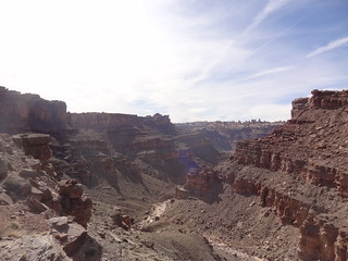
but canyon country is farther to the east and each canyon is too small, yet the
sheer number too big for the mind to really comprehend it.
The 4WD road diverges from Chimney Rock the way mountain trails do, before
finally turning back to meet it just as you are starting to despair from the
weight. Chimney Rock to me wasn’t very interesting. It was impressive that the
spire had formed, but now it just sat there through dry millenia, acting as
a waypoint in the confusing mass of canyons and mesas. There were several
caches of water left here by other parties. We found a nice cave and stashed
our rafts and associated implements there, then sat at the Chimney Rock
Trailhead and had lunch. It was now around noon.
A full stomach and a lighter pack are a huge boost to morale and speed, and the
fact that things literally went downhill from here really served us well. From
Chimney Rock, 3 trails head out. One goes east to take the long way back to the
Doll House, and two go north. Contrary to what the National Geographic map
says, both trails do not start west of Chimney Rock. Rather, the westward trail
is on the west of the rock and the eastward trail is on the east side. We
followed the one on the west. Head a little further north and true canyon
country immediately opens up. While the views had previously been dominated by
red rock, here the tops of the canyons were all yellow while the sides were
darker brown and it looked spectacular. The Chocolate Drops are quite obvious
and Maze Overlook ascends behind them. The trail immediately goes around one
small canyon and descends into the next. Descending the canyon is a very
interesting experience. All the Canyonlands trails try to be as direct as
possible, which meant we were either descending steep but smooth sandstone
walls by the magic of rubber soles, or going down big ‘steps’ where our packs
were a hindrance. Cairns mark the descent, but there are plenty of other rocks
scattered around, so be careful! During the descent we crossed a few pools of
water, but not expecting to find them, we had all the water we needed. Once at
the bottom, there begins 3 miles of walking on the sandy river beds of long dry
rivers. I have no idea whether these rivers are still active, but there at the
bottom it sure didn’t seem like any substantial flow had occurred on any human
timescale. About half way in, the trail joins up with the one coming from
Lizard Rock. While we were sure that we were at the right canyon, we could not
find the actual trail. Our destination of course was north, and that trail was
easy to find. Following the meandering river is an exercise in patience, and it
seems I wasn’t the only one growing irritable about that. The trail cuts
through the banks at nearly every turn, and this compacted sand was almost
a pleasure to walk on compared to the loose, deep sand in the river bed! Be
careful though, as prickly pears and other spiky plants might stab your feet.
Larger juniper and cottonwood trees lined this and several other river banks in
this part of the park.
Continuing on, we were vexed when Harvest Scene didn’t show up where it was
supposed to. The map was wrong again, Harvest Scene is not on the east of the
trail but actually on the wall to the ‘left’ (northwest). I must say that I was
expecting some sort of NPS sign or similar, but there was none, and the scene,
while beautiful, is at eye level and small. I had had the notion that it would
be something majestic, since everyone seemed to talk about it, and in that
sense I was disappointed. The paintings themselves are incredible though,
and almost alien in there depictions.
The ranger had said that camping was prohibited 1 mile around Maze Overlook,
and that Harvest Scene would be a good place to camp (not near it obviously),
but we wanted to press on to where the trail hits a wall and becomes
northwest-southeast, the left side going to Maze Overlook and Horse Canyon, the
right side going back towards Chimney Rock. There is a ‘Spring’ marked on the
map here and confirmed by the ranger (Cynthia?) as flowing. We reached this
intersection around 5pm. I come from the wetter areas of the world and my usual
stomping grounds are the Sierras, so I thought a spring would be emerging from
the rock and trickling as a little waterfall of clear water. Instead, the
spring was just a muddy trickle, that was lost underground a few hundred feet
east. Fortunately, heading a few hundred feet west, the water had collected in
a small ditch. It is likely that in late spring this water will be stagnant and
possibly smelly (unless it dries before that), but right now it was cool and
clear and I was okay with drinking it.
This ditch was just to the west of the trail intersections where the next
canyon on the west starts, seperated from the Harvest Scene trail canyon by
a small spur. In this canyon, ascend just a few feet up the river bed (south)
and a fairly clear path leads uphill (westward) to a rock platform. This
platform is a great campsite. It’s neither high nor low, fairly close to water
and on hard ground. The rock can sleep upto 3 people (don’t move the kitchen
platform in the center! :)) and two more can fit on the soil in the clearing.
There is a wall to the southwest, but there are great views of the
southwest-northeast canyon and the effects of sunset and sunrise are gorgeous.
In Beyond the Hundredth Meridian, Wallace Stagner quotes someone (too bad
I can’t find it right now), about how distances play tricks in the Plateau
Province, so that the air itself seems thicker and things seem more crisp, and
I had to agree.
While in the morning, and even until I reached the Harvest Scene, I had been
enthusiastic about a quick hike up to Maze Overlook, we were all exhausted by
this point and I too chose to stick to camp chores. I swear I poured out a half
a pound of sand from my shoes and socks! Meshy, low-cut trail runners and no
gaithers are not good desert wear. I should try sandals next time.
Roxana and me shared the tent today as she did not have the raft and other
items as insulation.
Day 3: We set off at 7:30 today. Today we would follow the eastern fork of the
trail back to Chimney Rock. We continued for 2 miles down the canyon system we
had been in since yesterday. Here the trail is easy to miss among the sandy
bottom and for a while the cairns are far apart. It is better to use the more
detailed Maze district map. The major landmarks are a few islands where the
trail proceeds to their left. Eventually the trail steepens and involves some
scrambling as it rises out of the canyon. There is one class 3 (easy, but
exposed and tipsy when wearing a pack) move to gain a ledge, then head left to
climb over a barrier. From here, bound up the cairned trail and you eventually
emerge on a mesa that will lead south to Chimney Rock.
This part of the trail is easily the most enjoyable of the trip. Minimum
elevation change and great slickrock make for easy walking, allowing you to
enjoy the views of the canyons on both sides, the Chocolate Drops and the rest
of Maze country spread out in the west and the La Sals gracing their presence
in the east. It is possible to make really good time here and we were at
Chimney Rock a little before noon.
Take a lazy break here, as the next part of the journey is equally inspiring
and terrifying.
After lunch, we retrieved our caches, bringing the packs back to their “stupid
heavy” weight and headed east on the trail that goes back to the Doll House.
The trail descends into a slickrock canyon that is ridiculously fun to descend.
Teetering masses of stone serve as stairs in certain parts, while other parts
require some scrambling, but the footing is sound and the journey is quick. Our
luck of cloudy mornings had held out today as well, but now the sun had broken
through and it was hot at the bottom of the canyon. Continue to follow the well
marked trail along the canyon. The Shot Canyon stream had pockets of water when
we were there, and in a wet year may even be flowing. Here the trail again cuts
through meadows rather than follow the meander and it is a good idea to keep an
eye out for cairns. At this point my raft was making a big deal of trying to
fall of my pack.
Eventually the trail will turn southeast (it has been heading northeast from
Chimney Rock down Shot Canyon). This turn takes longer to arrive than it looks
on the map, but again, the trail is well cairned and you should avoid worrying.
Here you’ll climb up several hundred feet, only to descend back down the other
side into Water Canyon. On the way down, the trail enters a narrow hanging
canyon. When it exits in a couple of yards, it is to a sheer drop into Water
Canyon. This is a beautiful spot to spend some time. Water Canyon is huge, and
green, and your seat is in a coveted place. Once satisfied with the view, turn
right to follow the ledge, which descends and takes a U-turn before descending
to the canyon floor.
True to it’s name, Water Canyon has a fairly large stream and water is assured.
At the bottom, leave the trail and head east, following the course of the
stream. Although not appearing on any maps, there is an obvious trail down to
the Green. Obvious does not mean easy though. About 1.5 miles before the
intersection with the Green the stream careens off the cliff.
Here the trail goes right and takes an adventurous path down over extremely
rotten rock. This sketchy trail should be approached with extreme caution.
There are several places where it narrows to have only enough place for one
foot. Gravel and sand abound to make footing unsure. Talus fields make up
whatever is left. Remember to avoid hiking below someone’s fall line as it is
very easy to kick of rockfall. The only consolation is that cairns mark the
way.
Set aside at least an hour for this half mile, 500 ft descent to the canyon
floor. Almost at the bottom of this adventure, the stream collects into a very
inviting pool. Unfortunately, short on time and having no beta of what lay
ahead, I forced the others to abandon this luxury, but you may want to make use
of it.
Once at the bottom, follow the stream until it starts flowing over solid
slickrock and the course of the Green is visible. About half a mile from the
intersection the stream will enter another pool. Here the route is confusing.
One way would be to enter this waist deep pool and wade through it, but you do
not know what the other side holds, and at least in March the water is cold.
But head up and look to left and you will see a cairn marking a trail following
the cliff.
A use trail also goes to the right (south) of the stream. DO NOT take this.
We did and ended up at a dead end near the Green resulting in a significant
detour to get back on track. After reaching this dead end I realistically
considered descending the cliff at a very prominent ledge system, but was shot
down by the others :)
The trail on the north side is fairly straightforward, although it can be
daunting at the end of an exhausting day. Soon you will reach the Green River.
Such a large body of water, flowing calmly through huge canyons was a wondrous
sight after 2 days in the dry desert. This is famous Stillwater Canyon, ahead
of which lie the rapids of Cataract Canyon. The trail does not immediately
descend to the river bank; Tamarisk trees have completely taken over this delta
and made the approach impassable. Instead, the trail goes north along the Green
for a few hundred feet and then descends to a sandy shore. Do not take the
first faint turn. The actual trail has a small area that would make a good
campsite right by the river.
We had originally hoped to reach Spanish Bottom today, finishing all 8 miles of
the river journey. The unexpected slow descent followed by going on the wrong
trail put us really behind schedule though and it was 6:30pm by the time we hit
the water. So our aim was to keep going while there was enough light and find
a campsite in one of many small canyons along the Green.
Not having a rain jacket, and not wanting to use my down jacket on a river,
meant that I was wearing only two thin layers. The wind was blowing and the
river was cold, so that I was quickly shivering.
This was my first major bit of rafting, since on day 1 we had simply crossed
the Colorado laterally. While I appreciate the stability of a raft, it’s thin
bottom is not very insulating, and it really lacks the fun manuevarability of
a kayak. The large bottom also means that whether stuck on a sandbar or when
launching off, it is pretty much impossible to shimmy to get the thing to move.
Strapping the pack horizontally (perpendicular to the raft and on top of the
(gunwales?)) is a better position as it allows your legs to be placed inside
the raft. I didn’t do this on day 3 and got uncomfortable quickly.
Having a closed cell foam pad is great since you can sit on it and further
increase insulation from the water.
Stillwater Canyon is easy to go through and you can easily spin around and take
in the surroundings as you let the river carry you at 1-2mph. Just make sure to
do some sandbar spotting before as there are several of these on the stretch to
Spanish Bottom.
One time something that was possibly an otter swam by us, and we saw a few
ducks, but otherwise it seemed like the 4 of us were the only living things on
the river. We did paddle frequently since we wanted to cover more distance,
finishing about 4 miles that day in 1hr 15min.
Here (see map), a sandy
beach large enough for several packrafts allows you to pull in. A well defined
trail leads up this to a ledge that is probably not meant for as many people as
the rafts. This ledge is wide enough for 2 people at the entrance, but narrows
to a space comfortable for 1 person and their stuff the rest of the way.
Pitching a tent is not a good idea since it just takes up too much space
(Michaela and Raj insisted). The wind was low and it wasn’t so cold once we
were out of the water, so I was happy to cowboy camp. The ledge does continue
around to face the Green, and while an excellent spot to sit down, I would not
trust myself to not roll of into the Green. More intrepid sleepers will find
that it is easy to fit 7-8 people here, based on how cosy or daring they are.
Other than the ledge, the rest of the small canyon has trees and a meadow.
There was no real place to hang the food, so that I just slept with it that
night. I didn’t expect any larger animals to come down into this canyon that
must see human habitation only infrequently. Rats I’d just have to live with.
(They ate Roxana’s food and left turds in her pot, mine seemed to be
untouched).
Day 4: Day 4 was an early start again. I have to commend the group on managing
to stick to our departures regularly, the small number of people definitely
helped. With the orientation, direct sunlight was going to be hard to come by
for a while, so that the campsite was quite cold at first light. The advantage
of sleeping with my food was that I could stay in my bag, eat, change and
pack while staying warm. Only once I was ready to go did I get out of it :)
We had tied all the rafts together and looped the rope around a rock - just in
case - and so they were all there waiting for us. We pushed off around 8am and
soon reached the confluence, where Green and Colorado meet to form a river that
will cross nearly half the continent before draining into the Gulf of
California. It is a surprisingly calm confluence, and the rising Sun
definitely raised our spirits after 3 days in less than ideal conditions.
Along the entire route of Stillwater Canyon red and yellow walls rise
majestically, as if trying to make up for the indifference of the desert by the
rugged beauty. Unless you are as dumb as a brick, Spanish Bottom is easy to
identify due to the large beach and familiar surroundings from 3 days ago, but
just in case, there is a sign board on the eastern bank a mile or so before it,
warning that the Cataract Canyon rapids are coming up and packrafters with no
prior experience better get out at the big beach up ahead. We pulled ashore
a little before 10 and spent 90 minutes resting, waiting for the rafts to dry
a bit, cleaning them up and filling up our water.
The final part of the journey reverses the first day’s route and I will not go
into the details. It is an arduous climb in the beginning, and with the
excitement of the upcoming trip gone, so does all energy and optimism. Just
slog through it.
Just before the trail intersects Devil’s Lane Raj seriously thought we
were lost since it was taking forever, and I was starting to have my doubts
too, inspite of a correct compass bearing and vaguely familiar terrain.
We were very happy then to come across a family of day hikers. To see other
humans after 2 days, ones that were clean and happy, really put a spring in our
step. They also assured us we were on the right track and indeed we quickly
emerged into the wide canyon.
We encountered a group of 3 teenagers who were heading to Spanish Bottom and
they didn’t have a map! I hope they made it through fine.
The table at Devil’s Kitchen was a welcome place to sit on, but after eating
through all our remaining food (those sausages were delicious!) we all returned
to the ground, the primal living of the last few days still dominating our
civilized selves!
From Devil’s Kitchen, which we reached around 2:30 and left at 3:30, it took us
another 2.5 hours to finish the last 3.5 miles of 4WD track. We encountered two
Texan 4WDs and their drivers on the way, who must have surely thought we were
idiots to be walking.
As much as the Needles district is stunning, towards the end of the trip I was
a mission to finish it and ignore everything around me that isn’t helping in
that task. I maintained an unnaturally fast pace to reach civilization as soon
as I can. It is funny how easy it is to ignore the calls of civilization out in
the wilderness, but once you know it’s near, how hard it is to keep away.
I reached the Elephant Hill TH at 6pm and we spent another 45 minutes while
everyone arrived and cleaned up. Then the long drive to Moab began with a quick
stop at Newspaper Rock and occasional gawking at the climbers still on the
cracks at Indian Creek.
“Thanksgiving Dinner” at the Moab Grill was heaven, even though CNN just
wouldn’t give up on MH370(?) in the background. We then headed next door to the
Big Horn Lodge and washed away the grime and sand. Hot showers are the second best
thing invented after restaurants!
Arches:
Breakfast with green chile at the Moab Diner was great. We were still
ravenous and went through a skillet each. This hunger was to haunt us the whole
day, supplemented by pita chips, chocolates, yogurt, strawberries, big honking
sandwiches and sugary candy that we munched on pretty much the whole time.
After washing and shipping the rafts we grabbed the food at CityMarket and
drove to Arches. We explored Arches like normal people do, avoiding getting out
of the car, driving to observation points, rolling down the window and taking
pictures. We still managed to get out 3 times, once to view Delicate Arch from the
upper viewpoint, once to get to Sand Dune Arch (beautiful and easy scrambled
to the top) and Broken Arch, and once to reach Double Arches
(again some fun scrambling). We had lunch (the BHS) at a nice picnic spot near
Broken Arch. After some wandering through the souvenir store, we began the long
drive to Salt Lake City around 4pm. We didn’t make the most of Arches, but
I think I’ll be coming back to Moab. That place is really happening!
A huge Chinese takeout dinner finally assuaged my hunger pangs and we slept for
a few hours before catching the early flights to familiar, relatively humid,
California.
Gear thoughts
This year, I’ve acquired some new gear in to cut down weight for
several upcoming trips. Below are thoughts on the gear that I used for the
first time on this trip.
MLD Cricket tarp
- I’ve had the MLD Cricket for a while, but this was the first extended trip
I’ve taken it on. I can’t comment on weather protection since the weather was
calm the whole time, but it’s ease of pitching is great! I usually keep the
center pole at 135cm and the door pole at 110cm. This is a good height to be
able to enter without touching my knees to the ground. It is also surprisingly
warm for being open on one side. One day it even acted as a comfortable
2 person tent. In this configuration, the center pole has to be put up vertical
and not at an angle. The second person does end up being a little outside the
tarp coverage, so it wouldn’t suffice in case of rain. I think if you were
comfortable getting really cosy, then the 2 poles could be arranged in
a V-configuration with space to squeeze in between.
The
groundsheet
i use with it also proved very durable for it’s weight and thickness (or lack
of it).
Zpacks Arc Blast - This
was my first time with my new, orange pack. It is the 60L variant with 1 hip
belt pocket, hiking pole carriers, ice axe loops and bungee cord over the mesh.
I was very impressed with it’s durability and load carrying capacity.
In spite of several scrambles on slickrock, it didn’t suffer any ruptures.
There is a small hole near the top where I think something from the rafting
gear may have pricked it, but it’s small enough to not bother even taping. It
is mightly stained though. The material is nowhere as tough as standard packs,
so I did ensure that on really bad descents I would take the pack off and lower
it.
Most impressive was that it didn’t completely collapse from carrying 40lbs when
it’s only rated to 30. I kept the frame straight to not load it. I have
a feeling the stitching at the top of the shoulder straps was stressed, but it
held up and I’ve had no problem in subsequent trips. I did not suffer any undue
shoulder pain or hotspots, and the wide shoulder and hip belts really helped.
The 1L side pocket is very useful since it is bigger than most backpack hip
pockets. I could fit the day’s snacks, knife, compass, headlamp and camera in
there. I might get another pocket though to keep things seperated a little and
avoid having one hip so heavy :)
The rolltop is secure and easy to use and allows great control over pack
volume, so that it can become as small as the stuff you are actually carrying.
Zpacks 10F quilt
- I replaced all the big 3 for this season since I’ve
a major trip later this year and each of them has performed wonderfully on this
trip. My 10F quilt is the 6’, regular size with 900fp down.
I am a side sleeper and I turn a lot, so I never bothered getting the zipper
below me. On the first day when it went below freezing, that part did let in
some cold since it’s not insulated. but I simply compromised by snuggling
deeper into the bag and cinching it around my head. This immediately made it
comfortable.
On the other 3 nights, I didn’t once have to zip it up completely. In fact
using the Ghost Whisperer down jacket for the torso and the bag for the legs
was enough. My legs remained warmed all the nights, even with just using my
empty backpack as ground insulation. (I was carrying the torso length part of
the Z-lite sol to save on weight and volume.)
Sawyer Mini - Performed
splendidly. The backflush syringe took care of Colorado silt. What I love about
the Mini is not having to filter all water at the source. I carried a 2L
camelbak as the clean reservoir, and a 2L Platypus as the dirty reservoir and
squeeze bottle. This allowed me to carry 4L but only expend effort into
filtering the dirty 2L when required. The ability to fill the camelbak without
taking it out of the pack is a big winner as is drinking straight from the
dirty bottle with the inline attachment.
One design decision that was disappointing is that the washer on the dirty end
is easy to lose while shaking the filter out. Mine flew into the trees on Day
3. Since this renders the filter ineffective, I’d expect it to be affixed much
more tightly. I was also disappointed that Sawyer did not get back to me about
what size of washer to use to replace it, despite several social media posts
and and email. Eventually, I got one from Lowe’s that required some scissor
work, and was a tight squeeze, but at least it won’t be flying off ever again.
I also carried a Smartwater bottle to add some more capacity in the desert and
allow easily filling the Platypus.
This is my one and only experience with Packrafts, so I can’t comment on them,
but I really wish manufacturers find a way to reduce the packed volume. We had
to spend several minutes and lots of energy trying to get them small and even
then they wouldn’t fit in the backpack with the other stuff, leading to
a unstable carry on the outside. Also maybe a teflon coating so the sand would
just slide off later? :)